References to Turnpike toll gates can be found in the first volume of St Albans' Own East End and on its website, although information about some of them and their houses are rather sketchy, including what they actually looked like. When travelling along the Hatfield Road from St Albans towards Hatfield travellers first encountered a gate at the Peacock PH opposite the present Marlborough Road. This was the start of the St Albans to Hatfield section of the Reading & Hatfield Turnpike. The price paid for travelling took you as far as Smallford at the crossroads (now a roundabout). But on the way the traveller would have passed three toll points of interest to those travellers wishing to take themselves, animals or carts from a side road onto the turnpike Road and onwards towards St Albans. All three were on the right: Camp Lane, The Rats' Castle and Colney Heath Lane; none was on the left.
 |
Because the borough boundary just reached this point east of the town we are fortunate to
capture Hatfield Road curving between left and right; Camp Lane joins it from lower
right. Ninedells Nursery was soon to be replaced by the Cavendish estate. The Granville
estate hasn't emerged either and the space at the top is still the Fete Field, predating
Clarence Park. Town map 1878.
COURTESY NATIONAL LIBRARY OF SCOTLAND |
 |
Close-up of the turnpike toll point (TP on the map above). Soon after 1878 plans would be laid for
the Crown Hotel and the emergence of Stanhope Road.
COURTESY NATIONAL LIBRARY OF SCOTLAND |
The purpose of these little side road tolls, as they were termed, was to ensure payment was made before venturing onto the main road. It would have been impractical for all side roads to be protected. They were placed where traffic was busiest and there it would have been financially worthwhile charging for the shorter distances before a user reached the next main road gate. After all, the cost of maintaining the main roads was borne by those using them, not by local authorities, before the 1880s.
The side road toll building we seem to know least about – no drawing, no painting, no photographic image, and no description – is the one where Camp Lane met Hatfield Road. The nearest landmark was St Peter's Farm, part of which, today the Conservative Club occupies. In fact I am not quite correct, for there are two known facts: tolls were collected only in the direction of St Albans; and it had three known names, the Chain Bar Toll, Hatfield Road Field toll, and the Fete Field toll. Early 25 inch maps do mark the location with a tiny black square, but that square could represent anything.
 |
This Ordnance Survey 25 inch map from 1897 covers the same area. Camp Lane had been made
up and renamed Camp Road; Stanhope Road has replaced the toll house opposite the Crown
Hotel; Clarence Park and Clarence Road is now on the scene, and the triangle of land,
informally called The Green will shortly be built on. The pond is not, however, shown.
COURTESY NATIONAL LIBRARY OF SCOTLAND |
However, the National Library of Scotland collection of Ordnance Survey maps does include a small number of Town Maps, and right on the eastern edge of the borough, extending as far as St Peter's Farm at today's The Crown, and standing on its own, is the toll house; a bold rectangle with a smaller attachment at the back. It is likely to have been a single storey structure; that assumption being on the basis that one of the toll keepers had accommodation at the cottage next to St Peter's Farm house.
Much change occurred during the twenty years since the 1878 town map was surveyed and the opening of Clarence Park in 1894. In the south-east corner was Ninedells Nursery soon to be sold to Frederick Sander for his housing and orchid nurseries. A little drive enters from the Hatfield road onto the Ninedells; this became the line of Albion Road and Cecil Road as the new houses of the Cavendish estate were build.
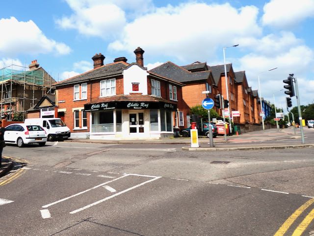 |
The toll house was just to the right of the two white vehicles at the beginning of Stanhope Road.
Camp Road is shown joining Hatfield Road ahead. |
 |
The pond has now been replaced by the first two shops on the left, opposite Albion Road, formerly
a track access to Ninedells Nursery.
COURTESY GOOGLE STREETVIEW |
 |
The access to the Ninedells Nursery extended to include the present day Cecil Road.
COURTESY GOOGLE STREETVIEW |
 |
Clarence Road was designed to meet the former toll house junction. A form of roundabout
enabled vehicles to use a road directly in front of the hotel to access the new Stanhope Road. So,
not a proper roundabout!
COURTESY GOOGLE STREETVIEW |
In the north-west a track left the Hatfield road, crossing the Fete Field diagonally towards the farm barns. Much of this field quickly became the recreation field of Clarence Park, but the location of the track can still be located along the park's Hatfield Road boundary, opposite the Granville Road junction.
 |
From inside the recreation section of Clarence Park the former entrance from Hatfield Road,
opposite Granville Road, can still be located; the gate and ramp down to the path was still
open until the 1960s. Although this image was taken some ten years ago the foliage is still
not as dense as other sections of the tree screen along the road. |
The largest single change is the laying of Clarence Road, designed to leave Hatfield Road from the bend at what was intended to be a form of roundabout, and the pond shown on the town map has now been replaced by the first two shops, 41 and 43 Hatfield Road.
An early newspaper report described the development which took place in Hatfield Road Field (the south-west sector of the town map). It stated that the shop, now Chilli Raj, which was built as a general store and post office, replaced a former toll house. The map evidence shows this not to be quite true. Its location appears to be on the line of Stanhope Road, which would have been a few years before the building of the little post office. Standing along the approach roads in turn leading to The Crown junction it is still possible to follow the various map lines edging the roads and tracks shown on the 1878 Town Map.


.jpeg)


.jpeg)
.jpeg)
